The John Muir Trail
- Colby

- Apr 6
- 16 min read
So the TL;DR. This trip was one of the most incredible things I have ever done. It was everything I thought it would be, and more. It was an amazing 14 days filled with everything you could think of: Fun, Beauty, Heat, Mosquitos, Thunderstorms, Pain, Twinges, etc. etc. etc.
Mostly my takeaways were this:
This is some of the most beautiful country in the world.
God is an amazing creator.
I am so fortunate and blessed to have spent 14 days in the backcountry with my oldest son.
Our young people CAN do hard things and not just succeed but thrive, we HAVE to give them opportunities to do it.
How it started:

How it finished:
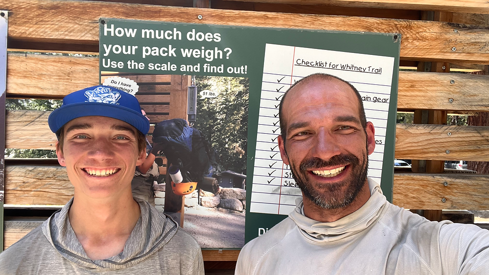
I started this trip with my oldest son (Ethan), a college roommate of mine (Trevor), and a good friend of his who became a good friend to all of us (Mike). The four of us were able to complete this hike together and we picked up some friends along the way. Below is a brief summary of our experience.
Timeline & Daily Summary:
June 29, 2024:
Drove from Utah County to the Whitney Portal, dropped off cars, carpooled to Mammoth and spent the night there. It was a long drive and my car displayed 116 degrees as we drove through Death Valley. But coming down into the eastern Sierra along 395 I was amazed to see the wall of mountains rising 13,000 feet plus in front of us. Stunning.

June 30, 2024:
We entered Yosemite through the Tioga Pass, picked up our permits, drove down to Yosemite Valley, got dropped off, hung out at the Backpackers Campground and walked around the touristy places.
You can pick up your permits a day early which I highly recommend. There is also a backpackers campground for a nominal nightly fee which was clutch for us to get started early and knock out the first day of our plan. I highly recommend both picking up your permits a day early and staying at the backpacker campground the night before you start. We explored Yosemite Valley and enjoyed all the sites, shops, and little museums. What an incredible place.


Day 1: 18.86 miles and 8,057ft of elevation gain
Started: Yosemite Backpackers Campground
Ended: Ridge before Sunrise High Sierra Camp

This was a really hard day coming out of Yosemite Valley. 8k feet of vertical gain should tell you all you need to know. We got Half Dome permits as a part of our JMT Permits, so we added that onto the trip. It was really cool! Those cables are no joke!


The hike after Half Dome was not fun. After the Clouds Rest junction there are many miles of burnout and we did that in the middle of the day. A fire came through that area a number of years ago, so while the undergrowth was thriving, trees have not started to grow back. So it was hot and very exposed. It was a relief to get to camp finally. We did about 2 miles more than planned as the original area I had planned to camp was mosquito ridden. So we went up the mountain a little further and it did make Day 2 a bit easier.


Day 2: 18.88 miles and 1,910ft of gain
Started: Ridge before Sunrise High Sierra Camp
Ended: Vogelsang Trail Junction (Lyell Canyon)
Day 2 was an easier day, once we crested the ridge after Cathedral Peak. It was pretty much all downhill the rest of the day with a slight, gradual incline through Lyell Canyon. We hit 9 miles by 10am (we'd wake up around 5am pretty much every morning) but we were also feeling it from the day before. Achilles pain, IT Band pain, feet, ankles, etc. I was nervous about how today and tomorrow (first pass) would go as a result of how hard we pushed ourselves.
Walking past Cathedral Peak and Cathedral Lakes was pretty amazing though.

We stopped in Tuolumne Meadows at the post office area to pick up a 4 day resupply and charge some of our electronics. We had mailed this weeks ago and were lucky with our timeline of the post office opening. It had been destroyed the year prior from the record snow levels and at the time we went through was being run out of a connex. We finished the last 7-8 miles to the Vogelsang trail junction without a problem. We met a few PCTers there and another South Bound (SOBO) JMTer named Flo (Florian) from France. We'd spend a lot more time with Flo toward the end of the hike.

Day 3: 14.81 miles and 3,127ft of gain
Start: Vogelsang Trail Junction
End: Thousand Island Lake
Day 3 brought our first pass, Donahue Pass. It was super buggy with Mosquitos on the way up. I don't know if it was because it was our first pass, but it was not a fun one at all. It felt harder than it should have, but that may have been due to the long first two days and lack of restful sleep. The mosquitos played a big part in that but it also wasn't super scenic either. Lyell Canyon is amazing and a joy to hike through. Easy trail, slight vertical incline and gorgeous.


This pass also marks the boundary out of Yosemite National Park. I don't remember much of the day except we made it to our destination pretty early which would be the theme of the trip. We'd get started early, get a good amount of miles in (to beat the heat), and arrive at camp somewhere between 1-4pm. It was actually really nice to get to camp early and just relax, get into the lakes or streams and soak our aching feet, take creek baths, and/or do creek laundry.
Thousand Island Lake is STUNNING. These pictures are good, but don't do it justice at all.


We met a couple of girls who had just graduated from UC Davis and decided to hike the JMT. They camped with us that night. One of them had never been backpacking in her life, the other had gone on two backpacking trips before...we found all levels of experience on the trail. Another guy from Japan joined us that night too.
Day 4: 19.22 miles and 2,915ft of gain
Started: Thousand Island Lake
Ended: Red's Meadow
Day 4 started beautifully!

We were making great time...until I realized I took us on the wrong trail for 1 mile, all downhill. Ugh. I was so frustrated with myself. We had to go back uphill 1 mile and then continue uphill for the route toward Red's Meadow. Even with the additional 2 miles (so upsetting) we felt we could still make it to Red's Meadow by lunch time and get a meal at their grill for lunch AND dinner. We pushed hard but made it. We passed Devil's Postpile, but didn't get close as we were in a hurry to make it for lunch. A really cool rock formation!

My wife ended up calling Red's Meadow and got us a cabin there for the night! Clutch. I also think it helped my son out who was still having a few physical challenges. The food really helped him too, he is definitely a food-motivated kid! So we gorged on lunch and dinner there and were able to sleep in beds that night and do some laundry. Red's Meadow has a bus that runs into Mammoth so a lot of hikers come in for food, then head to Mammoth to resupply or stay a night. It was fun to sit and talk with some PCT hikers that evening and hear their experience, nearly 900 miles into their journey.
Day 5: 15.61 miles and 4,096ft of gain
Started: Red's Meadow
Ended: Lake Virginia
We got started especially early this morning because Red's is pretty low in elevation and we knew were going to be climbing a lot. Thankfully the climb was pretty gradual so we were able to make really good time.

I think we got to Lake Virginia around 11:30am or Noon. It was another great day to just relax by the lake, take a nap, and clean up a bit. There isn't much that happened today. We met a couple of older ladies who came into camp around dinner. One of them, Diana, would join us the last few days of the trip, similar to Flo.

Day 6: 15.1 miles and 1,988ft of gain
Started: Lake Virginia
Ended: Vermillion Valley Resort
Not sure what happened but my watch didn't seem to record the activity on Day 6 so the stats I listed are what we "should" have done according to my route creation.
Lake Virginia in the morning was gorgeous.


We planned to get into Vermillion Valley Resort for the 4:45pm ferry from the trail, across Lake Edison, to the resort. VVR is a popular place for hikers to stop with two ferries, one leaving in the morning and the other in the evening. We planned to stay 24hrs there and rest up, eat, shower, do laundry, and relax. We didn't have many miles to do into Lake Edison so when we got to the junction we pulled over and took a nap. Mike was a little antsy so he ended up hiking the 6+ miles into VVR while we waited for the Ferry. He met us there with a big grin, excited to show us a little bit of paradise.
We did go up and over Silver Pass before descending to Lake Edison.


Day 7: 8.81 miles and 2,577ft of gain
Started: Vermillion Valley Resort
End: Random campsite over Bear Ridge
We stayed at VVR all day and took the 4pm Ferry out. My son and I got another room that night and it was nice. We also had our big resupply there for the remainder of the trip, 7 days. We sent big 5 gallon Home Depot buckets with our food and realized all that food would not fit into our bear cans. We both carried a BearVault 500 and had to toss some food away to fit everything. I didn't take any pictures but VVR was a great stop. The food was dang expensive but the sizes/portions were AMAZING. Super grateful to be able to stop there and do a little recovery.


We didn't do many miles coming out of VVR, but wanted to get over a gnarly ridge called Bear Ridge. That was not fun to do in the heat of the day with the sun beating on the ridge. Luckily we had decent tree cover. While in VVR we had WiFi and could see that the temperatures were +17 degrees higher than "average." We first learned here that there was a "Heat Dome" over the Sierras. It made sense now. It was hot and we hadn't had ANY cloud cover since the trip started.
Now the real JMT started. No accommodations, no "civilization" until we left and got out at the Whitney Portal on the 14th, and high passes every day. I was feeling a bit nervous, especially for my son. But boy he ended up being just fine. I left VVR with a pack weight of 32.5lbs (including our food and 2 liters of water) my son was at 33lbs (he carried a 1lbs chair the entire trip!). It was the heaviest we'd be all trip long.

Day 8: 19.98 miles and 3,075ft of gain
Started: Random camp over Bear Ridge
Ended: Near the broken bridge on the South Fork of the San Joaquin River
Today was a day we had been anticipating for a while. We'd essentially be going over a pass a day until the end of the trip and we added a bit to our plan on this day to try and ford the South Fork of the San Joaquin River. In the winter of 2023, the heavy snow broke a bridge here and this river is not an easy one to ford. It is narrow everywhere with a strong flow. I had been watching reports all spring and early summer. If we couldn't ford it, we'd be doing Andrew Skurka's "Up and Over" route which would had 2.5 miles and 1,200ft of gain, and was taking an average of 3hrs to complete. As we talked to PCT hikers coming North Bound (NOBO) our fears were calmed. Most people were easily able to ford it, so we did too.


Day 9: 19.38 miles and 4,246ft of gain
Started: Near the broken bridge
Ended: Below Muir Pass
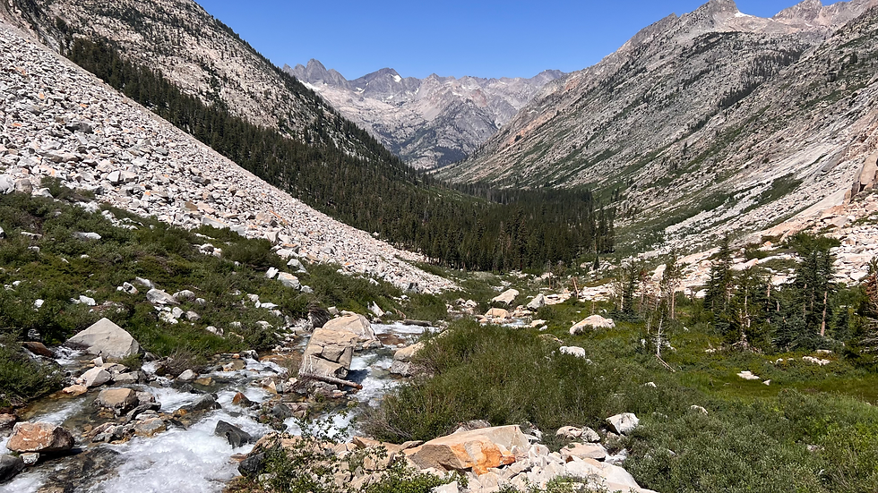
This was the day I was really looking forward to and probably my favorite day of the trip. We went up Evolution Valley, past Evolution Lake, over Muir Pass, and Muir Hut. This ended up being my favorite day on trail. There are three lakes that lead up to the pass, Evolution Lake, Sapphire Lake, and Wanda Lake. It was fun to hike past all of them and watch as they all flow down into each other. It was gorgeous.


We descended about 4 miles below the pass and hit a few places with snow on the trail, the most we'd see the entire trip. I was grateful to be descending on this side of Muir Pass. Going NOBO over Muir Pass would not have been very fun. It was brutal and relentless for those folks.

Day 10: 15.90 miles and 3,262ft of gain
Started: Below Muir Pass
Ended: Upper Palisade Lake
This was a no-pass day, although we made up for it by doing the Golden Staircase right before hitting our campsite. The Golden Staircase is a pretty brutal uphill to reach the Palisade Lakes. The rock is gold in color and the area is 100% exposed, so when the sun is shining it looks even more golden. Anyway, the trail after our campsite and through the valley was beautiful and had some of the nicest trail all trip long. The scenery was nearly as stunning as the day before.

We passed the "Muir Monster" and my son wanted a picture of us getting eaten. He calls it The Whale. It was a fun little break to spend with him there for a few minutes. This is a smaller iconic piece of the trail.


That night at camp Flo and Diana joined us. We had seen them off and on the past few days, but they decided to stick with us from here on out. It was fun to have others join us. While we hiked at different speeds during the day, we all stopped together and camped at the same place all the way to the end.
Day 11: 20.81 miles and 3,641ft of gain
Started: Upper Palisades Lake
Ended: Woods Creek
Today was the second hardest day for my son, outside of Day 1. Within 3 minutes of starting the day, we were crossing a stream with a waterfall and my son slipped and fell into the stream a bit. He lost a few things into the water that I was able to retrieve, but I think it really made him nervous as he could have fallen into a pretty swift-moving stream and into a bit of a whirlpool. Anyway, he banged up his knee and ankle a bit but came away unscathed, outside of being nervous about "what could have been."
It was a two-pass day. We did both Mather and Pinchot passes, then descended way down to Woods Creek and another iconic feature of the trail which is a small suspension bridge that is pretty wobbly to walk across. There were also bear boxes there, so we could put our bear cans in those at night which was nice.


Luckily the descent from Mather didn't take us very low in elevation so the climb up to Pinchot wasn't terrible. However about 1 mile from the summit my son, who I always kept ahead of me, turned and had blood pouring from his nose. I don't think he'd ever had a bloody nose before so he had no idea what to do. He had toilet paper in his pack so I set him down on a rock and told him to pinch it. After sitting for a while he said he was going to faint. His vision was getting black and his hearing sounded like he was underwater. I took his pack off of him and had him lean back on a flat rock. I was getting nervous. I didn't know what was going on and hoped that elevation sickness was not a problem. We still had another 12k foot, 13k foot, and 14.5k foot passes/mountains to do. There wasn't any easy way out either if things got serious. Once his nose stopped bleeding and he felt a bit better (we ate and drank a bunch) I had to exercise a lot of patience and just allow him to hike at his pace. We didn't stop on Pinchot Pass, just took a quick picture, and then descended quickly. Ultimately things worked out just fine, but I was a bit nervous with the two events that day.


Day 12: 16.24 miles and 4,920ft of gain (BIG DAY)
Started: Woods Creek
Ended: Bubbs Creek
There was a lot of gain on this day even though the miles were a bit smaller. We left Bubb's Creek and immediately hit about 2 miles of blow down/avalanche area where trees were all over the trail. It was challenging to find the trail in a few places while climbing up and over trees.

We were climbing up toward Glenn Pass and I was excited to go past the Rae Lakes which is a very popular and beautiful place to stay. We didn't stay there but the mosquitos were absolutely atrocious during this stretch. The Rae Lakes were absolutely stunning though.

The ascent up to Glenn Pass was a bit of a slog. This was my least favorite pass of the trip. I think part of it was that we couldn't see the summit until we were right near the top.

Nothing remarkable descending Glenn Pass to Bubbs Creek. Just pretty country and Bubbs Creek also had a bear box to put our stuff in. We met a woman there doing the PCT in sections. She had just retired from some Canadian government organization but she was likely quitting as the Sierras were just too much for her. She was certainly older and not in the best of shape, but I was impressed nonetheless with her determination.
Day 13: 21.28 miles and 5,172 ft of gain (HUGE DAY)
Start: Bubbs Creek
End: Guitar Lake
This was our biggest day. We had originally planned to stop a few miles short at Crabtree Meadows and camp there but decided to do a few extra miles to Guitar Lake and set ourselves up to sleep a little more before a sunrise summit of Whitney. The heat dome had passed and the day prior some temps were a little cooler and clouds had moved in. I had been getting weather reports through my Garmin InReach Mini 2, and there were chances of rain and thunderstorms that I was a bit nervous about.
As we started climbing up Forrester Pass (13,200ft!) we could see clouds starting to build that didn't look nice. The ascent was pretty mild actually with longer switchbacks that were not terribly steep, but about 10 minutes from the top the storm hit. We were getting hit by rain and cold weather ascending the switchbacks, luckily no lightning or thunder. It was cold, wet, and windy. I tried to take a picture of the pass like I have done on all of them, but in my haste ended up taking a screenshot instead of a picture. It was nuts up there.

However, as soon as we crested the summit and walked twelve feet to the other side the weather was amazing with a beautiful rainbow.

We descended Forrester and ran into a lot of people that day. We went through the Big Horn Plateau and stayed at a pretty high elevation. Once we hit Crabtree Meadows, we let my son decide whether to stop for the day or go onto Guitar Lake. One of the guys in our group offered him a Snickers and an extra backpacker's pantry breakfast, so after a little rest he decided to take the food and head to Guitar Lake.
We got there with about 90 minutes to spare. We set up camp, filtered water, got dinner going, and hunkered down as a big storm came through. Guitar Lake sits at ~11,500ft so we had no cover from this storm at all. Lots of rain, wind, and there was definitely lightning and thunder. It was at a 7/10 on the nervous factor and was wondering if my son was going to be ok. He ended up being just fine and was more annoyed that he couldn't get to sleep, haha! We were planning on waking up at 1:30am the next morning, so he just wanted to sleep.

The storm lasted about 2hrs them blew away and the rest of the night was just fine. It left us with a beautiful sunset.

Day 14: 16.2 miles and 3,481 ft of gain (LAST DAY!)
Start: Guitar Lake
End: Whitney Portal
We got up at 1:30am and started on the trail about 2am. It was a slog in the dark to get going, especially since you can't see too much. We saw a headlamp or two above us, but hard to see how the trail got from where we were to where the headlamps were. Anyway, there was a bit of a climb out of Guitar Lake but after that the switchbacks were super long and not very steep which was so nice. We eventually got to the junction where the trail from the backside of Whitney and the trail from the frontside (Whitney Portal) come together. That was at about 13,300 feet. The junction is a nice place to drop backpacks and hit the last 1.9 miles up to the summit. I had my son drop his pack. I carried water for him and a few snacks. I dropped my bear can which I put some of my heavy stuff in, so my pack was pretty dang light going up to the summit.
We got to the summit at about 5:20am which was 15-20 minutes before sunrise. It was amazing (and cold)!


The descent was... rough. 8.7 miles down and over 6,000ft of descent. There is a section called the 99 switchbacks and my son counted 97. Lots of people going up. The trail was beautiful though, I felt bad for all the people going up!

Trevor and Mike made it down about 20 minutes before Ethan and I. We finished at 10:30am and it was glorious. There is a grill there at the bottom that we made it to right in time for lunch, I kept baby wipes in my trunk to clean off with a clean set of clothes, we took Flo and Diana down to Lone Pine, and then we took off for home.


We drove from Whitney through Death Valley (my car said it hit 118 degrees!) through Vegas, and then finished in Ivins, Utah where my dad has a condo. We stayed there and showered and just crashed. I worked for about half day before getting in the car and driving back to Utah County.
What an amazing trip! I won't say once in a lifetime as I would love to do this again, but doing it with my 15yr old son was incredible. He was incredible! I have no idea if he will want to do anything like this again or not. Hiker amnesia needs to set in. I've noticed after these trips that I don't want to touch my gear or even think about backpacking for a few weeks, but then the "amnesia" kicks in and I start planning the next one.
This trip is still distilling on me and I am trying to process all of it. But ultimately it was another incredible adventure that I am so grateful for.
If you are still here and reading, you deserve a gold star! Thanks for joining me on the journey, hope this is fun for you to read.
Total Mileage (according to my Garmin watch): 240.06 miles
Total Elevation gain (according to my watch): 52,119ft of elevation gain
Total weight lost: 15lbs
Total Steps Taken: 525,827 steps
Have questions about this trail? Log in and drop your questions in the comments below.
Comments